
Why Control Rooms Need a Real-Time Common Operating Picture
For Traffic Management Centers, modern systems are only as resilient as the situational awareness inside the control room.
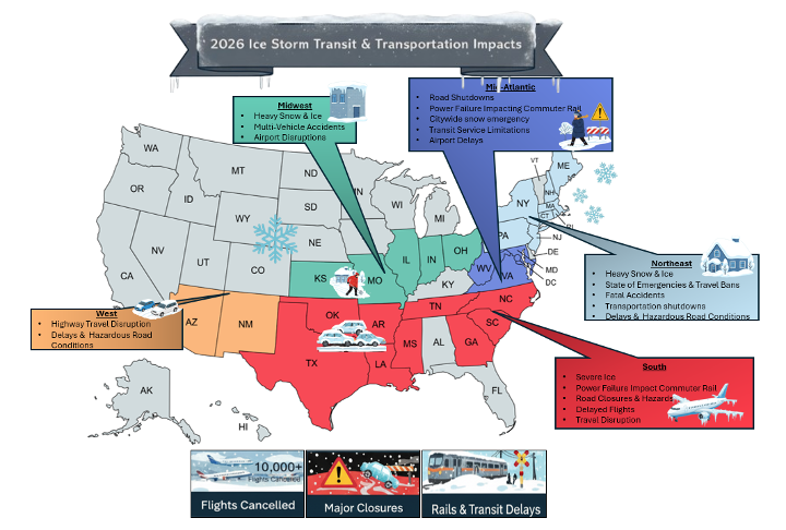
In early 2026, the United States experienced multiple severe winter weather events, including the January 23–27 North American winter storm, classified as a Category 3 “major” storm. The system brought heavy snow, sleet, freezing rain, and damaging ice accumulations of up to one inch in parts of the Southern U.S. The storm affected more than 30 states, stretching from the Southwest through the Midwest, Ohio Valley, Mid-Atlantic, and into the Northeast and New England.
Increasingly, counties and cities are relying on vis/ability to stay connected during severe weather events—enabling them to respond in unison, faster and smarter.
For transportation CIOs, operations directors, and control room managers, recent events reinforced the growing need for integrated platforms that unify real-time data across every system when it matters most.
The January 2026 storm affected more than 30 states, triggering emergency travel bans and interstate closures across the country.
Real-Time Monitoring During Ice Storms
When freezing temperatures and icy conditions develop, TMCs become the nerve center for roadway operations. Severe weather events expose a core challenge: critical data is often fragmented across dozens of disconnected systems. For transportation leaders, these storms reinforced the growing need for:
Real-Time Operational vis/ability
A single unified view across all transportation systems—sensors, cameras, weather feeds, and vehicle telemetry—surfaced in real time when operators need it most.
Integrated Transportation Technology
Platforms that connect, not silo—bringing traffic operations, road weather, fleet management, and GIS data together in one environment.
Faster Cross-Agency Coordination
Streamlined communication between DOT operations teams, law enforcement, emergency management, and public works—without the phone tag and delays that cost lives during storm events.
Weather & Infrastructure Integration
Better integration between weather intelligence systems and transportation infrastructure—so pavement condition data, forecasts, and sensor readings translate directly into operational decisions.
Key Systems Used by DOTs & Traffic Management Centers
When integrated with vis/ability, these data sources are unified into a single operational dashboard—enabling transportation leaders to detect hazards faster and coordinate response across agencies.

Traffic Operations Platforms
- IRIS
- Econolite Centracs
- TransCore TransSuite
- PTV Optima
- Flow Labs
Road Weather Information Systems
- Vaisala
- Campbell Scientific
- Lufft
Traffic Camera & Video Management Systems
- Genetec
- Milestone Systems
Crowdsourced Traffic Intelligence
- Waze
- Google Maps
Weather Forecasting & Transportation Decision Support
- WeatherSentry
- RoadCast
- DTN
GIS-Based Transportation Mapping
- ArcGIS
Snowplow & Maintenance Fleet Management
- SnowPaths
- TRAISR
- HTrack
Connected Vehicle & Transportation Data
- WxDE
- Operational Data Environment (ODE)
- Verizon’s Edge Transportation Exchange
- Platform Science
- Aeris Mobility Suite
Traffic Detection Sensors
- Miovision
- Iteris
Fleet Monitoring & Winter Maintenance
- Trimble
- Samsara

Unifies all 10 of these systems into a single operational dashboard—delivering real-time alerts and situational awareness to decision-makers when rapid response is critical. Also integrates with Q-SYS to ensure the right data reaches the right screens at the right time.
The Future of Transportation Operations Centers
As transportation networks grow more complex, agencies are increasingly adopting integrated operations centers and common operating platforms that unify data across multiple systems. Instead of forcing operators to navigate dozens of disconnected dashboards, vis/ability from Activu delivers a unified operational view across all transportation systems. This unified awareness enables transportation leaders to:
- Detect incidents faster
- Coordinate response across agencies
- Improve safety during extreme weather
- Reduce disruptions across transportation networks
When severe weather strikes, the difference between disruption and resilience often comes down to how quickly decision-makers can see the full operational picture.
Ready to Modernize Your Traffic Management Center?
Contact us or request a demo to see how vis/ability from Activu delivers next-generation situational awareness and operational resilience for traffic management centers.
Detect.
Coordinate.
Respond.
That’s the future of traffic management operations.